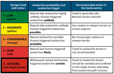
Avalanche Warnings in Switzerland to be modified starting this winter. The SLF is enhancing the precision by subdividing the danger levels. It will indicate whether the danger is towards the bottom end, in the middle or towards the top end of the reported level.
The SLF (Swiss Institute for Avalanche Research) says the new system will provide “users with more precise information for assessing the risk”.
The five danger levels themselves remain unchanged.
The Avalanche Warnings in Switzerland will have subdivisions of the danger levels to indicate where the danger is in the level:
Towards the bottom end (-)
More or less in the middle (=)
Towards the top end (+)
This subdivision is only applied for dry avalanches, and only starting at Level 2.
The purpose is to make it easier for users to interpret the Avalanche Warnings in Switzerland correctly.
Other national avalanche forecasting bodies are watching the change closely.
Avalanche warning scale
The SLF explains the new situation in a series of questions and answers:
Why this change?
The SLF has been hearing calls for a more precise representation of the avalanche danger for several years.
For those who engage in snow sports, Level 3 in particular spans a very broad spectrum.
The avalanche forecasters likewise have been wanting to pinpoint the danger with greater precision for some time.
These wishes have now been satisfied with the introduction of the subdivisions.
Why not simply add a danger level?
Additional danger levels would not be feasible in the international arena and would serve little purpose in any case.
According to avalanche forecaster Kurt Winkler, “One advantage of the new system is that it takes findings of psychological research into account.”
The human brain cannot differentiate more than five to seven defined classes.
The danger levels, which are clearly defined, are already aligned with this understanding and are thus being retained.
The classification reflects logical and therefore slow thought processes.
But we can also determine, without any difficulty, a relative ranking within the individual classes.
We make subdivisions of this kind intuitively and thus quickly.
Does the new approach work in practice?
The SLF’s avalanche forecasters have already been allocating subdivisions to all danger assessments over a period of six winters, but has refrained from publishing them.
This large data set was then statistically analyzed in order to review the new approach.
The analysis clearly showed that the differences between the danger level forecast in the avalanche bulletin and the observations reported from the field are much smaller when the subdivision forms part of the picture as well.
In addition, a clear correlation was shown to exist with objectively measurable factors that play a role in the formation of avalanches.
From one subdivision to the next one above, for example, the frequency of whumpfing sounds and of avalanches triggered by people increases and the snowpack stability test results deteriorate.
Since the experimental series also demonstrated that subdividing the danger levels is dysfunctional in the case of wet snow avalanches, subdivisions are not being reported when the snow is wet.
Where the graphical reduction method is being applied, the subdivisions can be taken into account by entering the diagram on the left or right side of the column representing the danger level and then using the diagonal color code.
What is the target audience for the subdivisions and how can they be useful?
Everyone can benefit from the additional information which is provided.
“Those who wish to avoid the most dangerous situations on a given winter’s day can simply stay away from regions where the danger level is 3+ or higher, for instance, and instead either choose to visit a region where the danger is lower or even make other plans for the day,” explains Kurt Winkler.
The subdivisions can be used quantitatively as well.
The calculation of the avalanche risk on the website skitourenguru.ch, for example, takes them into account.
The subdivisions can also be useful when applying the graphical reduction method.
For an approximate assessment, the danger level can still be used in such cases.
Alternatively, based on the subdivision, the user can enter the diagram on the left or right side of the column representing the danger level and then use the diagonal colour code.
Can the new subdivisions be disregarded?
Although, as with any forecast, incorrect assessments are possible, evaluations show that the subdivisions reflect the danger more accurately as a rule.
Disregarding the subdivision bars access to additional information that would facilitate a better assessment of the risk.
“In any event, it is essential to continue taking the danger level seriously,” concludes Kurt Winkler.
“A 3-minus remains a level 3 and indicates ‘considerable avalanche danger’ – it is not to be taken lightly or treated as though it were a 2.”
Tajikistan Avalanche Early Warning System – A Life-Saving System. Georgia Tech engineering student Mirza Samnani volunteered over 1,000 hours to develop early warning systems for avalanches in Tajikistan.
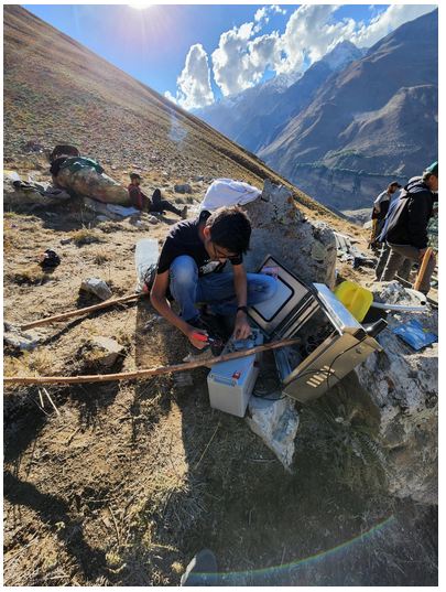
Samnani hiked over 9,200 feet — three times — to install two weather stations in the village of Manem in Tajikistan. This project has the potential to affect more than 1 million people in hundreds of villages in the high mountainous regions of Central and South Asia including Tajikistan, Afghanistan, and Pakistan that are prone to avalanches every winter. It can also be scaled to other parts of the world where avalanches pose a high risk.
Samnani was contacted by a member of Madad, a nonprofit organization that works to save lives within communities that are vulnerable to climate change. The group came across his previous work building life-saving robots for a hospital in his hometown of Mumbai, India, during the pandemic. Seeing his love for helping others and his engineering skills, they invited Samnani to join Madad.
High mountain regions in Central Asia, Karakoram, Hindu-Kush, and the Himalayas are prone to snow avalanches. Their frequency and intensity are expected to increase due to atmospheric warming. The lack of a village-level avalanche early warning system poses a significant challenge in warning communities for timely action to avert disaster. Currently, local volunteers manage weather monitoring posts, where they manually track temperature, rainfall, and snow depth.
The early warning system Samnani worked on has seven different sensors. They monitor weather and environmental conditions, including wind speed and direction, atmospheric pressure, temperature, humidity, rainfall, snowfall, solar radiation from the sun, solar radiation absorbed from the ground, snow depth, and seismic activity. These conditions help calculate the snowpack parameters and, based on the trigger threshold, the algorithm determines when to disseminate an alert or warning about a Tajikistan Avalanche.
The project faced uncertainty because of the rough terrain as well as strict regulations and policies in the region. Even after extensive testing, communication and power issues occurred, but these problems ended up serving as learning opportunities that ultimately improved the Tajikistan Avalanche system.
“This project presented me with a unique opportunity to utilize my engineering skills to develop a system to predict the risk of an avalanche. In just 10 months our engineering team took this project from concept to installation. I am excited for the data that we will receive from these pilot units in the upcoming months. I plan to continue to work with this project and other important projects that will help improve the quality of life for people living in poor or dangerous conditions,” Samnani said.
Currently, he and the group are collecting and monitoring the data being received from each warning system tower and studying the integrity and performance of the towers. In the next few years, more of these stations will be deployed to cover more than 600 high-risk villages in central and south Asia and eventually will incorporate sirens and text and phone alerts.
New avalanche nonprofit will provide financial aid for Forest Service
NH (Nov. 15, 2022) – Friends of Tuckerman Ravine and White Mountain Avalanche Education Foundation, both longtime nonprofits of Mt. Washington Valley, have merged. The merger will support and promote the Mount Washington Avalanche Center, a Forest Service operation.
Both groups have previously been critical to the success of the Forest Service center, bestowing financial support. This combined entity will enhance the ability to raise money.
“We are very excited about these organizations finally coming together after so many years. Both have the same goals, and now together, we can streamline our efforts to fund the Avalanche Center,” said Jake Risch, president of the new Avalanche Nonprofit – the Mount Washington Avalanche Center Foundation.
This fall, MWAC will host various events in support of the Forest Service :
The 12th annual Eastern Snow and Avalanche Workshop takes place on Nov. 17–18
Winter Backcountry Kickoff Party took place on Nov. 19, in Intervale, NH.
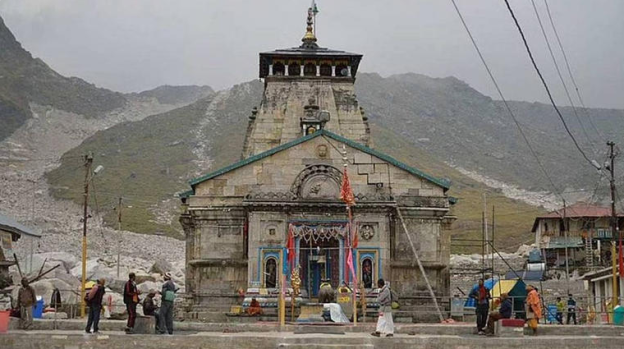
Kedarnath avalanches: An expert committee was formed by the Uttarakhand government to probe a series of Kedarnath avalanches in the past two months. They advised a complete ban on construction of buildings and temporary shelters on the “highly unstable and active debris slope above (the) Kedarnath temple”.
A report was submitted to the government which told the government in Uttarakhand to instead build concrete wedges and mounds on the higher slopes above the temple. This would reduce the momentum of avalanches originating about 5-6 km above the shrine.
Three Kedarnath avalanches were reported from the hills surrounding the shrine in Uttarakhand’s Rudraprayag district, between 22 September and 2 October. All were reportedly at a distance of 3-4 km from the temple site.
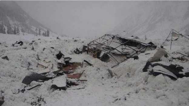
Last year, on 23 April, a temporary shelter housing labourers working for the Border Road Organisation (BRO) killing 16 people. A few months later, on 2 October, seven mountaineers lost their lives in an avalanche near mount Trishul.
In 2013, flash floods and landslides in the Kedarnath area wreaked havoc, killing many.
The expert committee report also mentions other avalanches from further back. One was in October 1998, which killed 27 pilgrims. Another happened on 23 June, 2008, when 20 people, including eight pilgrims, were severely injured. More than 100 lives have been lost in avalanches in the higher hills of the Chardham region in the past 10 years, according to the report.
On 1 October, following two of the past months’ three avalanches, the Uttarakhand government constituted an expert committee to undertake geological, glaciological, and geomorphic investigations around Kedarnath.
The five-member panel included the executive director of Uttarakhand State Disaster Management Authority (USDMA) Piyoosh Rautela, Wadia Institute of Himalayan Geology scientists Manish Mehta and Vinit Kumar, and Indian Institute of Remote Sensing’s C.M. Bhatt and Pratima Pandey — were tasked with ascertaining the causes of recurring avalanches in the area, assess risk factors and suggest remedial measures.
In its report, the panel recommended a “complete ban” on construction of any form on the highly unstable and active debris slope. Including scree fans (fan-shaped rock fragments). Construction activities at such heights may “lead to changes in direction and slopes of the unconsolidated materials” between the avalanche sites and the shrine.
The report also recommended slope modification and structural changes on the slopes.
“Benching of the slope at different elevations along the steep gradients of snow drift or channels to the north of Kedarnath temple would reduce overall slope angle and retard the velocity of downward movement of snow and debris mass” added the report.
It was also suggested that concrete wedges be constructed along the mid-slope of avalanche chutes to prevent and divert the forces, for “total protection from avalanche hazard”. The design, size and number of these structures would be decided after detailed field studies.
Kedarnath avalanches – Origin in glaciers
According to the report, the three recent Kedarnath avalanches originated 6 kilometers above the temple. From the peaks of the Companion Glacier adjacent to the Chorabari Glacier.
The town of Kedarnath is located on the outwash plains of Chorabari and Companion glaciers. The channels of the Mandakini river originate from Chorabari and Saraswati. It flows down from Companion glacier, encircling the plane terminating towards the south of the temple — the meeting point of the two rivers.
According to the report, “These streams (Mandakini and Saraswati) are observed to actively erode their banks. Avalanche is a major threat in the higher altitude regions.”
The Chorabari lake burst triggered a devastating 2013 flash flood.
Three recent Kedarnath avalanches and others in the past came from the accumulation zone of the Companion Glacier.
Deposition zones of these avalanches are located 5 km uphill of the Kedarnath temple. The avalanche activity poses little or no threat to the temple township. Appreciable snowfall was experienced over high-altitude areas in September. The accumulation of heavy snow on top of the ridges facilitated avalanche events to the north of Kedarnath.
The report emphasized that “presence of several avalanche chutes in the accumulation zone of the Companion Glacier suggests that the glacier is mainly avalanche-fed and avalanches are common for that glacier.”
Was the Uttarkashi avalanche triggered by an earthquake a couple days earlier? A 2.5 magnitude earthquake jolted the region on October 2. Just two days before the deadly avalanche hit the group from Nehru Institute of Mountaineering (NIM) at Draupadi ka Danda. Sixteen bodies were recovered by Thursday afternoon, fifteen were still reported missing.
The earthquake epicenter was not far from the Uttarkashi avalanche site. Experienced mountaineers as well as locals are now speculating that the earthquake may have triggered the avalanche.
According to National Center of Seismology the earthquake happened at around 10:43 am on October 2 with its epicentre in Bhatwari tehsil, Uttarkashi district. Significantly, the 25-km trek to Mount Draupadi ka Dana also lies in Bhatwari tehsil.
“Sometimes, even small tremors can cause cracks in the glaciers and the upper layer of snow could dislodge immediately after a small amount of pressure is exerted on it. In the past, we have seen earthquake-triggered-avalanches like the 2015 avalanche around the Mt Everest base camp,” said Love Raj Dharmshaktu, who has scaled Everest seven times.
The SE part of Uttarkashi district, including Bhatwari, falls under either zone IV or zone V of the seismic zone map. Senior geologist and executive director of Uttarakhand State Disaster Management Authority, Piyoosh Rautela, said that earthquakes do trigger avalanches and landslides.
He added: “A detailed investigation is needed to ascertain whether the October 2 quake, which was of low intensity, triggered the Uttarkashi avalanche on October 4.” Jayendra Rana, president of Uttarkashi trekking and mountaineering association, said, “Draupadi ka Danda is a safe peak and we have never heard of any major avalanche there. The October 4 incident occurred just two days after the quake. I think this angle should be explored.”
Indian Avalanche Survivor Aakash Lalwani, one of the rescued climbers, said the wall of snow took everyone down in a matter of seconds and threw them into a deep crevasse. “We were lucky that we could somehow breathe”.
A training expedition in the Himalayas was hit by a massive avalanche on a steep range in northern India, killing at least 16 and leaving about 10 others still missing.
About 15 people had been rescued as of Thursday, two long days after the expedition from the Nehru Institute of Mountaineering (NIM) were caught in the avalanche.
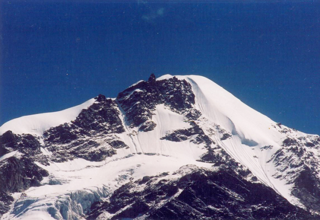
The avalanche struck around 17,000 feet near Mount Draupadi ka Danda-II as the team was returning from the summit. Draupadi ka Danda-II is in the Uttarakhand region.
Most of the Indian avalanche survivor are still in shock according to Vivek Pandey of the Indo-Tibetan Border Police.
Heavy rain and snowfall has limited both air and ground rescue efforts. On Wednesday a halt was called to rescue operations. The weather also posed a challenge to retrieving the bodies of those who died, officials said.
“Considering weather and other conditions, it is a difficult operation, which might continue for a couple of days,” Pandey said.
Many of the missing trainees were trapped in the 60- to 70-foot crevasse for at least two hours. “The hopes of survival are very bleak as the golden period of rescue in such situations is not even a couple of hours,” he said.
Among the dead was accomplished climber Savita Kanswal, the first Indian woman to summit Mount Everest and Mount Makalu. Kanswal, 27, was serving as an instructor on this week’s expedition.
Fourteen trainees were also among those killed, officials said.
Two Indian Air Force helicopters were sent to the region for the search.
Fatal climbing accidents are common in the Himalayas. In August, the body of a mountaineer was recovered two months after he fell into a crevasse while crossing a glacier in nearby Himachal Pradesh.
Oct. 7, 2022
Draupadi Ka Danda II. Photo: Amar Chandra/Wikimedia Commons
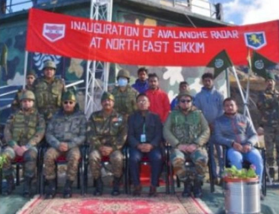
Gangtok: The Indian Army and the Defense Geoinformatics and Research Establishment (DGRE) have jointly installed the Avalanche Monitoring Radar, first of its kind in India, in north Sikkim, defence officials said on Friday. Besides being used for detection of avalanches, this Sikkim avalanche radar can also be employed to detect landslides.
Defence spokesman Lt. Col Mahendra Rawat said that the radar was inaugurated by Tri Shakti Corps commander, Lt Gen Tarn Kumar Aich, at one of the forward posts of the army at an altitude of 15,000 feet in north Sikkim.
The Sikkim avalanche radar has the capability to detect avalanches within three seconds of their triggering and will assist in saving valuable life of troops and civilians as also vehicles in super high altitude areas, he said.
Lt. Col Rawat said that the avalanche radar was made operational by Defense Research and Development Organisation’s wing DGRE, which is involved in forecasting and mitigation of avalanche hazards faced by Indian Army in the Himalayan region.
He said that this radar uses a series of short micro wave pulses which are scattered at the target and can detect an avalanche in less than three seconds.
The radar, which can permanently scan the targeted slope for avalanche release and track its path and its size in case it is triggered, can “see” through snow, fog as well as in the night, making it an all weather solution and covers an area of two sq/km obviating the requirement to place additional instruments in dangerous avalanche prone areas.
The radar is also linked to an alarm system enabling automatic control and warning measures in case an avalanche is triggered. Images and videos of the event are automatically recorded for future analysis by the experts.
Pragativadi News Service Sep 24, 2022
Special Radar Installed In Sikkim To Detect Landslides, Avalanche
Can we use Artificial Intelligence for Avalanche Forecasting?
Even the best forecasters only reach about 75% accuracy in their avalanche predictions. After all, they are only human. One of the greatest challenges is in the fact that avalanche danger cannot be precisely measured or communicated. It is, therefore, a matter of expert assessment and opinion by humans.
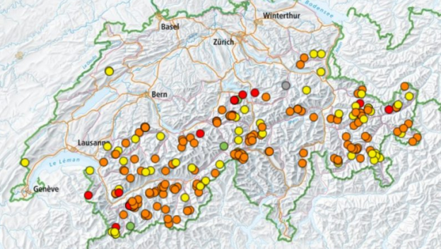
Last season the Swiss Institute for Snow and Avalanche Research successfully tested a first-of-its-kind, artificial intelligence computer program to assist in its avalanche forecasts. The SLF is a world leader in the field of avalanche forecasting and pushes the boundaries of avalanche forecasting methods.
SLF human observers collect measurements from over 120 different remote automatic weather stations located across the Swiss Alps. They then analyze the data, make interpretations, and combine opinions into a single bulletin published at 5 pm each day.
SLF researchers tested the new AI model as a “second opinion” against the human-made forecasts. In many cases the model agreed, but sometimes it did not. The differences are then reviewed.
The new Artificial Intelligence for Avalanche Forecasting model was trained using more than two decades-worth of weather and forecast information. SLF researchers now estimate the program is about 75% accurate in its model predictions. SLF forecaster Frank Techel describes the Artificial Intelligence for Avalanche Forecasting:
“The computer analyses the data in a different way than we do. That’s why it occasionally arrives at a slightly different conclusion. The computer forecast is very useful, especially for drawing exact boundaries between regions in which different danger levels prevail.”
The model, however, is limited to dry-snow avalanches. The SLF is planning on introducing a new Artificial Intelligence for Avalanche Forecasting system capable of modeling wet-snow avalanches as well as snowpack stability next season.
A brave dog, presumed dead in an avalanche, was found alive several days later at a trailhead.
An avalanche triggered by a skier in Colorado hit a skier and snowboarder on Thursday, and their dog.
The skier deployed an airbag before being partially buried under snow. However, they lost sight of their four-legged friend amidst the chaos.
Fortunately for the skier and snowboarder, they were uninjured and able to make it out under their own power.
After looking all over for the dog presumed dead in the avalanche, the owners and a search crew had basically given up hope.
They left the scene and assumed the dog had died in the avalanche.
Search and rescue members didn’t see any signs of tracks.
Miraculously, however, after several days of being missing, the dog was found at a trailhead of Monarch Pass.
The reunion was incredibly emotional.
This isn’t the first time a pet has been rescued after dire circumstances in the Colorado mountains this season.
In December a video posted on YouTube showed skiers digging out a dog who had been under snow for 20 minutes after an avalanche.
Despite the positive outcome this time, Lazar reaffirmed that the best course of action when caught in an avalanche was for riders to keep an eye on their pet and only attempt to save them once it’s safe to do so
“We don’t want dogs to wear avalanche transceivers. We want people to be searchable by transceivers and not mixable with potential dogs with transceivers on,” Lazar said.
That’s one story that this courageously good boy or girl will remember for the rest of their dog years.
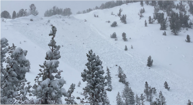
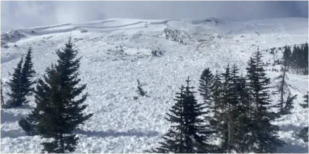
Site where a dog presumed dead in an avalanche was buried.