Avalanche Warnings in Switzerland to be modified starting this winter. The SLF is enhancing the precision by subdividing the danger levels. It will indicate whether the danger is towards the bottom end, in the middle or towards the top end of the reported level.
The SLF (Swiss Institute for Avalanche Research) says the new system will provide “users with more precise information for assessing the risk”.
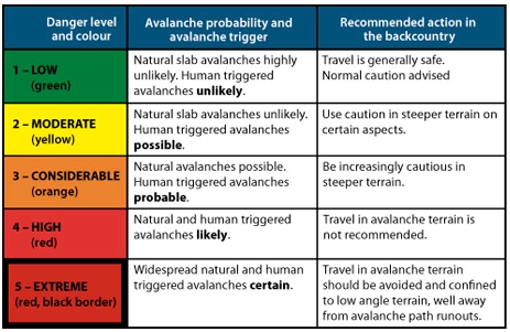
The five danger levels themselves remain unchanged.
The Avalanche Warnings in Switzerland will have subdivisions of the danger levels to indicate where the danger is in the level:
- Towards the bottom end (-)
- More or less in the middle (=)
- Towards the top end (+)
This subdivision is only applied for dry avalanches, and only starting at Level 2.
The purpose is to make it easier for users to interpret the Avalanche Warnings in Switzerland correctly.
Other national avalanche forecasting bodies are watching the change closely.
The SLF explains the new situation in a series of questions and answers:
Why this change?
The SLF has been hearing calls for a more precise representation of the avalanche danger for several years.
For those who engage in snow sports, Level 3 in particular spans a very broad spectrum.
The avalanche forecasters likewise have been wanting to pinpoint the danger with greater precision for some time.
These wishes have now been satisfied with the introduction of the subdivisions.
Why not simply add a danger level?
Additional danger levels would not be feasible in the international arena and would serve little purpose in any case.
According to avalanche forecaster Kurt Winkler, “One advantage of the new system is that it takes findings of psychological research into account.”
The human brain cannot differentiate more than five to seven defined classes.
The danger levels, which are clearly defined, are already aligned with this understanding and are thus being retained.
The classification reflects logical and therefore slow thought processes.
But we can also determine, without any difficulty, a relative ranking within the individual classes.
We make subdivisions of this kind intuitively and thus quickly.
Does the new approach work in practice?
The SLF’s avalanche forecasters have already been allocating subdivisions to all danger assessments over a period of six winters, but has refrained from publishing them.
This large data set was then statistically analyzed in order to review the new approach.
The analysis clearly showed that the differences between the danger level forecast in the avalanche bulletin and the observations reported from the field are much smaller when the subdivision forms part of the picture as well.
In addition, a clear correlation was shown to exist with objectively measurable factors that play a role in the formation of avalanches.
From one subdivision to the next one above, for example, the frequency of whumpfing sounds and of avalanches triggered by people increases and the snowpack stability test results deteriorate.
Since the experimental series also demonstrated that subdividing the danger levels is dysfunctional in the case of wet snow avalanches, subdivisions are not being reported when the snow is wet.
Where the graphical reduction method is being applied, the subdivisions can be taken into account by entering the diagram on the left or right side of the column representing the danger level and then using the diagonal color code.
What is the target audience for the subdivisions and how can they be useful?
Everyone can benefit from the additional information which is provided.
“Those who wish to avoid the most dangerous situations on a given winter’s day can simply stay away from regions where the danger level is 3+ or higher, for instance, and instead either choose to visit a region where the danger is lower or even make other plans for the day,” explains Kurt Winkler.
The subdivisions can be used quantitatively as well.
The calculation of the avalanche risk on the website skitourenguru.ch, for example, takes them into account.
The subdivisions can also be useful when applying the graphical reduction method.
For an approximate assessment, the danger level can still be used in such cases.
Alternatively, based on the subdivision, the user can enter the diagram on the left or right side of the column representing the danger level and then use the diagonal colour code.
Can the new subdivisions be disregarded?
Although, as with any forecast, incorrect assessments are possible, evaluations show that the subdivisions reflect the danger more accurately as a rule.
Disregarding the subdivision bars access to additional information that would facilitate a better assessment of the risk.
“In any event, it is essential to continue taking the danger level seriously,” concludes Kurt Winkler.
“A 3-minus remains a level 3 and indicates ‘considerable avalanche danger’ – it is not to be taken lightly or treated as though it were a 2.”