Category Archives: avalanche warning

Avalanche Warnings in Switzerland Modified

Avalanche Warnings in Switzerland to be modified starting this winter. The SLF is enhancing the precision by subdividing the danger levels. It will indicate whether the danger is towards the bottom end, in the middle or towards the top end of the reported level.

The SLF (Swiss Institute for Avalanche Research) says the new system will provide “users with more precise information for assessing the risk”.

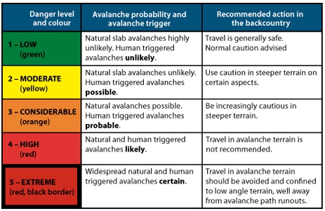
The five danger levels themselves remain unchanged.

The Avalanche Warnings in Switzerland will have subdivisions of the danger levels to indicate where the danger is in the level:

  • Towards the bottom end (-)
  • More or less in the middle (=)
  • Towards the top end (+)

This subdivision is only applied for dry avalanches, and only starting at Level 2.

The purpose is to make it easier for users to interpret the Avalanche Warnings in Switzerland correctly.

Other national avalanche forecasting bodies are watching the change closely.

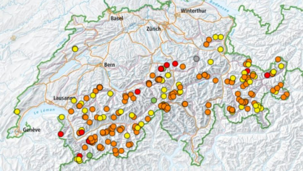
Avalanche Warnings in Switzerland
Avalanche warning scale

The SLF explains the new situation in a series of questions and answers:

Why this change?

The SLF has been hearing calls for a more precise representation of the avalanche danger for several years.

For those who engage in snow sports, Level 3 in particular spans a very broad spectrum.

The avalanche forecasters likewise have been wanting to pinpoint the danger with greater precision for some time.

These wishes have now been satisfied with the introduction of the subdivisions.

Why not simply add a danger level?

Additional danger levels would not be feasible in the international arena and would serve little purpose in any case.

According to avalanche forecaster Kurt Winkler, “One advantage of the new system is that it takes findings of psychological research into account.”

The human brain cannot differentiate more than five to seven defined classes.

The danger levels, which are clearly defined, are already aligned with this understanding and are thus being retained.

The classification reflects logical and therefore slow thought processes.

But we can also determine, without any difficulty, a relative ranking within the individual classes.

We make subdivisions of this kind intuitively and thus quickly.

Does the new approach work in practice?

The SLF’s avalanche forecasters have already been allocating subdivisions to all danger assessments over a period of six winters, but has refrained from publishing them.

This large data set was then statistically analyzed in order to review the new approach.

The analysis clearly showed that the differences between the danger level forecast in the avalanche bulletin and the observations reported from the field are much smaller when the subdivision forms part of the picture as well.

In addition, a clear correlation was shown to exist with objectively measurable factors that play a role in the formation of avalanches.

From one subdivision to the next one above, for example, the frequency of whumpfing sounds and of avalanches triggered by people increases and the snowpack stability test results deteriorate.

Since the experimental series also demonstrated that subdividing the danger levels is dysfunctional in the case of wet snow avalanches, subdivisions are not being reported when the snow is wet.

Where the graphical reduction method is being applied, the subdivisions can be taken into account by entering the diagram on the left or right side of the column representing the danger level and then using the diagonal color code.

What is the target audience for the subdivisions and how can they be useful?

Everyone can benefit from the additional information which is provided.

“Those who wish to avoid the most dangerous situations on a given winter’s day can simply stay away from regions where the danger level is 3+ or higher, for instance, and instead either choose to visit a region where the danger is lower or even make other plans for the day,” explains Kurt Winkler.

The subdivisions can be used quantitatively as well.

The calculation of the avalanche risk on the website skitourenguru.ch, for example, takes them into account.

The subdivisions can also be useful when applying the graphical reduction method.

For an approximate assessment, the danger level can still be used in such cases.

Alternatively, based on the subdivision, the user can enter the diagram on the left or right side of the column representing the danger level and then use the diagonal colour code.

Can the new subdivisions be disregarded?

Although, as with any forecast, incorrect assessments are possible, evaluations show that the subdivisions reflect the danger more accurately as a rule.

Disregarding the subdivision bars access to additional information that would facilitate a better assessment of the risk.

“In any event, it is essential to continue taking the danger level seriously,” concludes Kurt Winkler.

“A 3-minus remains a level 3 and indicates ‘considerable avalanche danger’ – it is not to be taken lightly or treated as though it were a 2.”
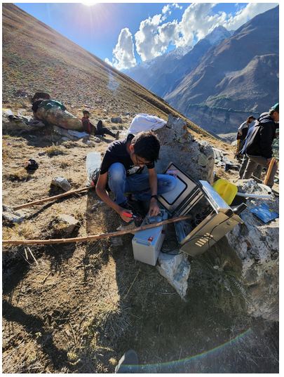
Tajikistan Avalanche Early Warning System

Tajikistan Avalanche Early Warning System – A Life-Saving System. Georgia Tech engineering student Mirza Samnani volunteered over 1,000 hours to develop early warning systems for avalanches in Tajikistan.

Samnani hiked over 9,200 feet — three times — to install two weather stations in the village of Manem in Tajikistan. This project has the potential to affect more than 1 million people in hundreds of villages in the high mountainous regions of Central and South Asia including Tajikistan, Afghanistan, and Pakistan that are prone to avalanches every winter. It can also be scaled to other parts of the world where avalanches pose a high risk.

Samnani was contacted by a member of Madad, a nonprofit organization that works to save lives within communities that are vulnerable to climate change. The group came across his previous work building life-saving robots for a hospital in his hometown of Mumbai, India, during the pandemic. Seeing his love for helping others and his engineering skills, they invited Samnani to join Madad.

High mountain regions in Central Asia, Karakoram, Hindu-Kush, and the Himalayas are prone to snow avalanches. Their frequency and intensity are expected to increase due to atmospheric warming. The lack of a village-level avalanche early warning system poses a significant challenge in warning communities for timely action to avert disaster. Currently, local volunteers manage weather monitoring posts, where they manually track temperature, rainfall, and snow depth.

The early warning system Samnani worked on has seven different sensors. They monitor weather and environmental conditions, including wind speed and direction, atmospheric pressure, temperature, humidity, rainfall, snowfall, solar radiation from the sun, solar radiation absorbed from the ground, snow depth, and seismic activity. These conditions help calculate the snowpack parameters and, based on the trigger threshold, the algorithm determines when to disseminate an alert or warning about a Tajikistan Avalanche.

The project faced uncertainty because of the rough terrain as well as strict regulations and policies in the region. Even after extensive testing, communication and power issues occurred, but these problems ended up serving as learning opportunities that ultimately improved the Tajikistan Avalanche system.

“This project presented me with a unique opportunity to utilize my engineering skills to develop a system to predict the risk of an avalanche. In just 10 months our engineering team took this project from concept to installation. I am excited for the data that we will receive from these pilot units in the upcoming months. I plan to continue to work with this project and other important projects that will help improve the quality of life for people living in poor or dangerous conditions,” Samnani said.

Currently, he and the group are collecting and monitoring the data being received from each warning system tower and studying the integrity and performance of the towers. In the next few years, more of these stations will be deployed to cover more than 600 high-risk villages in central and south Asia and eventually will incorporate sirens and text and phone alerts.

Tajikistan Avalanche Project

Dec 01, 2022 — Atlanta, GA

Sikkim Avalanche Radar Installed

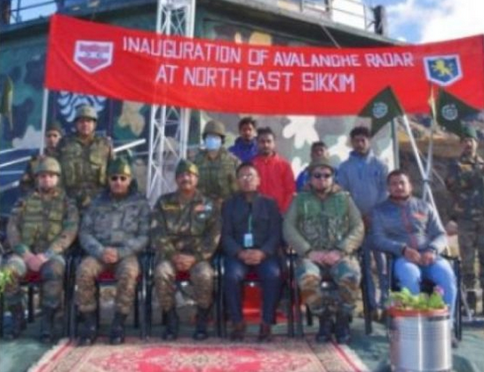
Gangtok: The Indian Army and the Defense Geoinformatics and Research Establishment (DGRE) have jointly installed the Avalanche Monitoring Radar, first of its kind in India, in north Sikkim, defence officials said on Friday. Besides being used for detection of avalanches, this Sikkim avalanche radar can also be employed to detect landslides.

Defence spokesman Lt. Col Mahendra Rawat said that the radar was inaugurated by Tri Shakti Corps commander, Lt Gen Tarn Kumar Aich, at one of the forward posts of the army at an altitude of 15,000 feet in north Sikkim.

The Sikkim avalanche radar has the capability to detect avalanches within three seconds of their triggering and will assist in saving valuable life of troops and civilians as also vehicles in super high altitude areas, he said.

Lt. Col Rawat said that the avalanche radar was made operational by Defense Research and Development Organisation’s wing DGRE, which is involved in forecasting and mitigation of avalanche hazards faced by Indian Army in the Himalayan region.

He said that this radar uses a series of short micro wave pulses which are scattered at the target and can detect an avalanche in less than three seconds.

The radar, which can permanently scan the targeted slope for avalanche release and track its path and its size in case it is triggered, can “see” through snow, fog as well as in the night, making it an all weather solution and covers an area of two sq/km obviating the requirement to place additional instruments in dangerous avalanche prone areas.

The radar is also linked to an alarm system enabling automatic control and warning measures in case an avalanche is triggered. Images and videos of the event are automatically recorded for future analysis by the experts.

Pragativadi News Service Sep 24, 2022

Special Radar Installed In Sikkim To Detect Landslides, Avalanche

Artificial Intelligence for Avalanche Forecasting?

 Can we use Artificial Intelligence for Avalanche Forecasting?

Even the best forecasters only reach about 75% accuracy in their avalanche predictions.  After all, they are only human. One of the greatest challenges is in the fact that avalanche danger cannot be precisely measured or communicated. It is, therefore, a matter of expert assessment and opinion by humans.

Last season the Swiss Institute for Snow and Avalanche Research successfully tested a first-of-its-kind, artificial intelligence computer program to assist in its avalanche forecasts. The SLF is a world leader in the field of avalanche forecasting and pushes the boundaries of avalanche forecasting methods.

SLF human observers collect measurements from over 120 different remote automatic weather stations located across the Swiss Alps. They then analyze the data, make interpretations, and combine opinions into a single bulletin published at 5 pm each day.

SLF researchers tested the new AI model as a “second opinion” against the human-made forecasts. In many cases the model agreed, but sometimes it did not. The differences are then reviewed.

The new Artificial Intelligence for Avalanche Forecasting model was trained using more than two decades-worth of weather and forecast information. SLF researchers now estimate the program is about 75% accurate in its model predictions. SLF forecaster Frank Techel describes the Artificial Intelligence for Avalanche Forecasting:

The computer analyses the data in a different way than we do. That’s why it occasionally arrives at a slightly different conclusion. The computer forecast is very useful, especially for drawing exact boundaries between regions in which different danger levels prevail.”

The model, however, is limited to dry-snow avalanches.  The SLF is planning on introducing a new Artificial Intelligence for Avalanche Forecasting system capable of modeling wet-snow avalanches as well as snowpack stability next season.

Those interested in learning more about avalanche safety or science can visit the Avalanche Center (avalanche-center.org) and its affiliated Avalanche Institute for online courses.

Can we use Artificial Intelligence for Avalanche Forecasting?
Can we use AI for Avalanche Forecasting?

Juneau Avalanche Danger: officials recommend residential evacuations

Historic Juneau Avalanches Possible

Sat, Feb. 27 – Juneau’s urban avalanche forecast is for “extreme” Juneau avalanche danger as of Saturday evening. There is a potential for “historic avalanches” in residential areas. City officials recommend that residents in the avalanche zone in downtown Juneau evacuate their homes.

The advisory also recommends that residents avoid avalanche paths including the Flume Trail. “People need to make their own safety decisions,” it stated. “But we feel that with the forecast for the next 24 – 48 hours natural avalanches are likely and of great size.”

The city and the Red Cross will open Centennial Hall as an emergency shelter. The doors opened at 8:00 p.m. on Saturday. COVID-19 mitigation measures are in place.

Juneau Avalanche Warnings were issued Friday

Juneau city officials said on Friday that there is a potential for “historic avalanches”. Depending on temperatures and how much snow falls, the city’s Urban Avalanche Advisory could be raised to an “extreme” Juneau avalanche danger, which is the highest level on the scale.

“I have never forecasted an extreme avalanche condition,” said Tom Mattice, the city’s emergency programs manager. He advised residents to be cautious, especially near the Behrends Avenue avalanche path.

Mattice says they’ve recently seen avalanches of snow four to six feet deep throughout the region. “In the urban environment, if we have a four foot deep avalanche that’s wide enough across the face of the Behrends path, (then) that’s more than enough to hit houses,” he said.

Widespread Activity and increased hazards

The Alaska Department of Transportation & Public Facilities has warned of increased avalanche hazard along Thane Road. Residents along the road should be prepared for an extended road closure if crews are unable to safely remove any avalanche debris.

The Coastal Alaska Avalanche Center says they’ve already seen widespread avalanche activity all around Juneau. They expect more avalanches over the weekend.

Rain Crust

A freezing rain crust has formed on top of recent snow that fell on a weak snow layer. The snow’s weakness can even be triggered from a flat spot. “And then, it’ll travel through that freezing rain crust and collapse the looser snow below and the denser snow above. So it can travel great distances. We’ve already seen avalanches that have traveled over a quarter mile just from propagating through the snowpack.”

They’re warning people heading out to the backcountry to use extreme caution. Even in terrain that is generally considered safe from any avalanches.

He says the unstable snowpack conditions could potentially last through the rest of the season.

Juneau Avalanche Danger
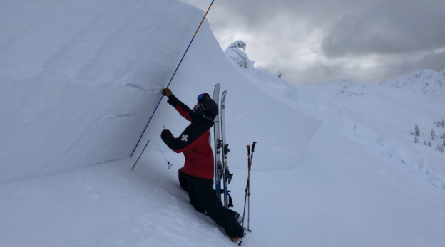
A ski patroller examines snow layers during avalanche mitigation. (Coastal Alaska Avalanche Center)

Atal Tunnel Avalanche blocks Manali-Leh highway

Heavy snowfall crippled normal life in tribal Lahaul and Spiti district today. An Atal Tunnel avalanche occurred on the Manali-Leh highway but no loss of life or property damage was reported.

Due to heavy snowfall in the region yesterday, the threat of snow avalanche had been looming on the Manali-Leh highway. Between the Solang valley and Keylong in the Lahaul valley.

  100-m stretch hit

  • BRO officials said snow avalanche covered a 100-m stretch of road near the South portal of the tunnel.
  • The snow avalanche was 265 cm high, which has blocked the highway completely even for emergency vehicles between Manali and Keylong.
  • The BRO has pressed its workforce and machinery into service
Atal Tunnel Avalanche
Site of the Atal Tunnel Avalanche, Jan 2021

According to sources in the Border Roads Organisation (BRO), a snow avalanche has covered 100-metre stretch of the highway. It was near the South portal of the Atal tunnel on the Manali-Leh highway. (MSP-12). The snow avalanche was 265 cm high. It blocked the highway completely, even for emergency vehicles, between Manali and Keylong.

The BRO authorities have pressed into service its workforce and machinery to clear the highway for traffic movement.

According to the report of the District Disaster Management Authority, Lahaul and Spiti, 35.65 cm of fresh snowfall was reported at Sissu. At Jispa it was heavier at 38.01 cm. In Udaipur 10.16 cm of snow was reported during the day.

Due to the snowfall, traffic movement in Lahaul and Spiti came to a standstill. The residents of the Lahaul valley were cut off from the rest of the state after the road beyond the Solang valley towards Lahaul was blocked.

The Snow and Avalanche Study Establishment (SASE), Manali, has issued an avalanche alert for the coming days. As a result, the deputy commissioners of Kullu and Lahaul-Spiti have issued an advisory for common public to avoid venturing into snowbound areas.

The movement of tourists has been restricted towards the Solang valley from Manali beyond Nehru Kund.

Severe Avalanche Risk in BC backcountry

‘Your life is not worth that day of powder skiing’: Officials warn of severe avalanche risk.

This has been a deadly week in B.C.’s backcountry. On Monday two snow bikers were killed in an avalanche near Pemberton. Then on Thursday a backcountry skier fell into a tree well and died near Whistler.

“I’m taking some time off to let the snowpack settle out,” said Whistler skier Mike Douglas. “It’s gotten really really dangerous.”

When Douglas was touring with some friends in “safe manageable terrain” they released a slab.

This is a good week to stay out of the Whistler area backcountry. We discovered some very easily triggered soft slab sitting on a layer of surface hoar today. 50cm crown on 30 degree N slope at 1500m. Likely to get worse. Be careful. pic.twitter.com/it0I2OblZO
— Mike Douglas (@MikeDski) December 31, 2020

“We kicked off a small slab avalanche with about a 50 cm crown,” he said, “it kind of spooked us a little bit, like wow it’s actually even more touchy out here than we thought.”

Twitter photo during severe avalanche danger
Twitter, MikeDski

Avalanche Canada is warning this is not the time to be in the backcountry. They are reminding those who want to venture out, to check forecasts before going. There is a severe avalanche risk right now.

“We’re on the storm track right now,” said Ilya Storm. “Right now, in some ways, the decision making is easiest.”

Meaning just don’t go! Because the high avalanche risk rating means it’s natural avalanches are likely and human triggered are very likely.

“It is snowing heavily, the wind is blowing, you can see it, you can see the snow accumulate and there are obvious clues out there,” he said. “Snow hates rapid change. The rapid change is a person. A person on a snowmobile, a person on skis, that can be enough to tip the balance.”

Douglas said this is the time to ski in bounds.

“Your life is not worth that day of powder skiing,” he said.

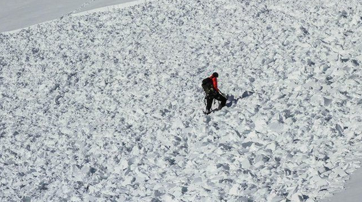
Photo on an avalanche. There is severe avalanche risk now.
Avalanche Photo

Avalanche Center Warns of Deadly Conditions as Storms Arrive

The high pressure over Utah is finally breaking down and snow showers are expected this weekend. While that’s good news for the ski resorts, the conditions in the backcountry will become dangerous – even deadly conditions could exist.

Since the first snow of the season has fallen,  there have been a lot of sunny days and a lot of clear, cold nights. What that’s done to the snowpack, according to Utah Avalanche Forecaster Trent Meisenheimer, is created the first condition for avalanche.

“We have generally shallow snow throughout the mountains,” says Meisenheimer. “What that creates is a very strong temperature difference in our snowpack right, so the ground stays relatively warm about 32 Fahrenheit and with that shallow snow the surface of the snow can be very cold like in the single digits cold. And that creates that big temperature difference across a very shallow layer of snow. And what that does is it makes our snow weak, or a term that gets thrown around a lot is faceted. Now what faceted snow is, is it takes that you know beautiful snowflake that falls out of the air and over a few days, it’ll actually become more square and angular, the shape of the crystal –  and it’s just like rock salt or sand  -if you could think about it that way. So, anywhere you look right now, and you see white snow on those hills it’s generally faceted snow. It’s become loose and sugary and weak.”  

Avalanches are created when snow is faceted, and a slab of new snow drops on top of the old, rotten snow.

“And a slab can just be anything that’s a little bit more dense than the snow underneath it,” he explains. “And as you heard, we’re expecting storms starting Friday morning and then lasting it looks pretty good all the way through Christmas with snow stacking up in the mountains. Now,  what this is going to do is it’s just going to raise our avalanche danger so because of that new snowfall, we’re gonna add a slab and now we’ve got avalanches throughout the mountains.”

No problem today – but this weekend things will change.

“Coming into the weekend, we’re gonna start building a slab on top of that weak layer and avalanches will become more likely,” he says. “So, what this means for us and what we need to do, is moving into the weekend, we need to be aware that this week snow exists and when we do get that stronger snow on top – we need to tone it down. So, that means sticking to slopes under 30 degrees in steepness. And really important, especially with weak layers, is that we don’t want to be under big slopes either because even if we’re standing on flat terrain and there’s that big, steep, hill above us, we can actually trigger the avalanche from below and have that avalanche come down on top of us.”

No one should be in the backcountry without a transceiver, probe,  a shovel – and a partner.

Utah avalanche center photo, US Forest Service
US Forest Service Photo

Highest avalanche situation level in East Tyrol

Piedmont, Italy - Extreme avalanche situation
Extreme avalanche situation in the Alps

The extreme avalanche situation in East Tyrol was made clear by an avalanche on Saturday evening in Prägraten am Großvenediger. Four houses and one vehicle were damaged. People were not injured. There were other snow avalanches with individual damaged buildings.

The Tyrolean avalanche warning service “imposed” avalanche warning level 5, i.e. very high risk, over East Tyrol. Spontaneous avalanches are to be expected from high catchment areas in the course of the day. In isolated cases they could also be extremely large. But at the same time, the head of the avalanche warning service, Rudi Mair, calmed down a bit. Due to the relatively warm temperatures and sometimes a lot of rain, wet snow avalanches in particular are to be expected, not powder avalanches. The latter would cause greater damage.

The emergency services also had to fight on all fronts due to the enormous rainfall in the state. Governor Günther Platter (ÖVP) assured East Tyrol financial support. District chief Olga Reisner appealed to the population to stay at home.

Lots of fresh snow in Carinthia

In Carinthia, enormous amounts of fresh snow in the Lesach Valley, the Gail Valley and the Upper Möll Valley. This resulted in roadblocks and an extreme avalanche situation. The milder temperatures in lower elevations caused some slopes to slide. Mudslides also blocked the road. The SPÖ regional councilor and disaster control officer Daniel Fellner appealed to the population in all areas affected by the weather to stay in their homes.

All emergency vehicles from the road maintenance depots were in constant use. Fellner asked the population in Upper Carinthia to adhere to the orders of the emergency services: “Please stay in your houses and do not climb the snow-covered roofs to shovel them free”.

After avalanches, some roads were closed, while snow chains were compulsory on others. In the course of the afternoon and towards evening, the snow in Lower Carinthia increasingly turned into rain showers. For the night it was expected that the precipitation would subside, but there should be some stormy wind in the Karawanken valleys.

New highs

According to the first data evaluation, the 24-hour fresh snow amounts at some ZAMG weather stations in the affected areas of the two federal states were in the record range. A “record” was even exceeded. In Umhausen in the Ötztal (1,030 meters above sea level) it snowed around 80 centimeters from Saturday to Sunday, the record for 24 hours there was 45 centimeters from October 2013. Measurements have been made here since 1956.

On the Brenner (1,400 meters) it snowed around 90 centimeters from Saturday to Sunday (record: 100 centimeters, measured in March 1975). In St. Jakob / Defereggen (East Tyrol, 1,283 meters) there was a snow cover of 110 centimeters on Sunday morning, in Döllach in the Upper Mölltal (Carinthia, 1,071 meters) of 97 centimeters and in Sillian (East Tyrol, 1,081 meters) of 89 centimeters.

According to ZAMG, it snowed around 100 to 150 centimeters from Friday to Sunday morning on the mountains of Upper Carinthia, East Tyrol and in the area of ​​the main Tyrolean Alpine ridge. Sometimes a little more. There will be another 50 to 100 centimeters of fresh snow by Monday, according to the forecast. After that, the situation should ease. The foehn storm still reached more than 100 km / h in the mountains on Sunday morning.

(apa, Wiener Zeitung Online)

Obergurgl, Tirol, Austria - extreme avalanche situation
Obergurgl, Tirol, Austria

Avalanche accident kills 1 in Switzerland

Dec. 8, 2020

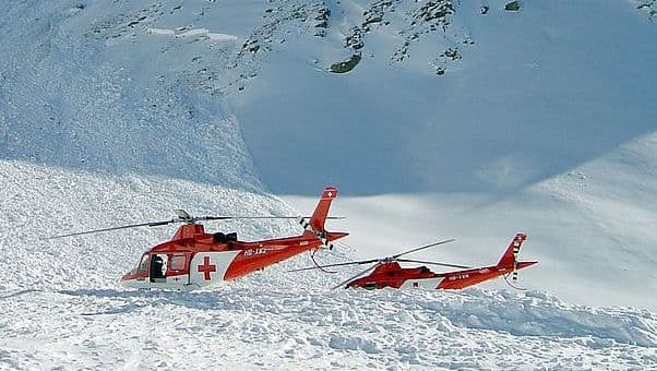
Swiss avalanche accident rescue
Stock image, SLF

BERLIN (AP) — An avalanche accident killed one skier in Switzerland.

Authorities in the Swiss canton of Nidwalden said one off-piste skier among a group of five people was killed in an avalanche accident Monday in the Titlis area, south of Lucerne. Rescue teams were not able to resuscitate the 23-year-old Swiss citizen after he was rescued.

The victim died on the scene near the Titlis mountain. Two others, out of five, were also hit but managed to free themselves without serious injury.

The group was skiing off-piste when the avalanche struck at around 10.15am. An investigation into what triggered the avalanche is ongoing.

A 23-year-old German man was also injured in an avalanche accident Monday in Austria’s Hahnenkamm skiing region in Tyrol. He went skiing on a closed slope. He was taken by rescue plane to a hospital in Kempten in Bavaria.

In a broad swath of the Alps in Switzerland, authorities raised the avalanche warning level to 3 on a five-point scale. Exceptionally heavy snowfall was dumped over the weekend. Some higher elevations recorded between 50 and 80 centimeters (20-32 inches) of snow over the last three days.

Snow Pummels Austria, Italy, Germany and Switzerland

Several roads were still closed in Tyrol and some valleys were cut off from the rest of the country. Electricity provider Tinetz said 4,000 homes lost power after several electrical lines were snapped by snow or fallen trees, public broadcaster ORF reported.

Austria issued avalanche warnings Tuesday for the country’s mountainous east after days of heavy snow pummeled the region.

Northern Italy saw massive snowfall over the weekend and snow also hit parts of Germany and Spain as well.

“It’s true that it’s early for the season” to have so much snowfall, said Mikhael Schwander, a meteorologist with Swiss weather service MeteoSuisse. He said the higher the elevation that the snow fell, the greater the risk of avalanches — although that also depends on other factors including the temperature and the types of snow on the ground.

According to SRF Meteo there is an elevated avalanche threat throughout northern Ticino, including Centovalli, and in the southern valleys of Graubünden and the Upper Engadine. In these regions, it’s a Level 4 on the five-part danger scale.

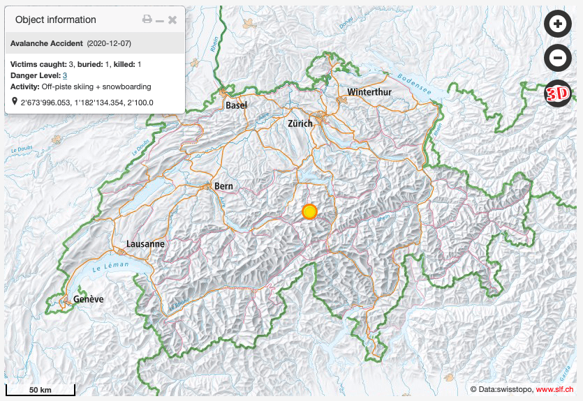
Location of avalanche accident
Location map, from Swiss SLF

Related: