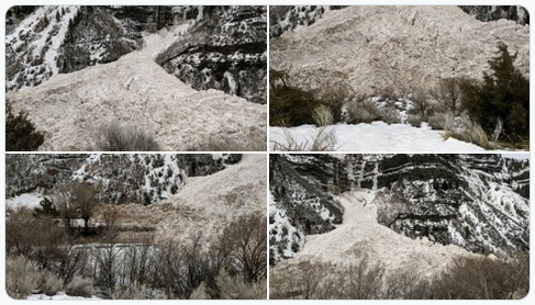
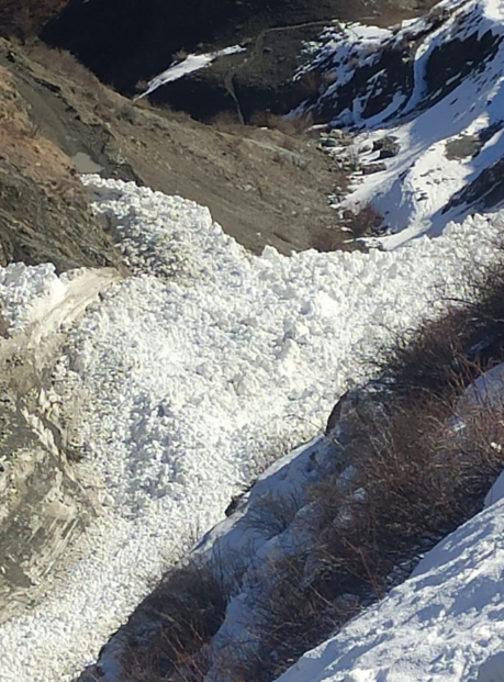
A Provo Canyon avalanche ran into the Provo River at Bridal Veil Falls. It left an enormous pile of snow and debris in the Provo River.
UDOT’s traffic camera in the area showed just how massive the pile was. People could be seen walking along the river’s border.
The canyon had been closed in the morning for avalanche mitigation. US 189 was reopened at approximately 11 a.m.
Though the roadway was opened and not obstructed, authorities shared concerns about drivers slowing down or stopping to get a better view of the incident. The Utah Highway Patrol issued a statement telling “motorist(s) not to stop on the shoulder of the roadway. It has caused some dangerous conditions.”
The Provo Canyon Avalanche apparently happened sometime in the morning hours ahead of the planned avalanche mitigation.
It didn’t become clear how massive the slide was until after it was fully lit by sunlight.
Authorities with UDOT didn’t express a high level of concern over the event. In a statement UDOT noted that “there was a pretty big slide that went right down Bridal Veil Falls, but didn’t affect the road. We’ve set off a few additional avalanches, but nothing too major just yet.”
A Provo Canyon avalanche ran into the Provo River at Bridal Veil Falls.
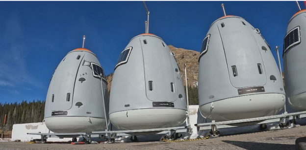
Avalanche mitigation spaceships will be used on Colorado mountain highways.
The egg-shaped devices lined in a row in the parking lot at the Eisenhower-Johnson Tunnels loom like spaceships getting ready for liftoff.
“Looks a little like the CDOT space force this side of the road,” said winter operations manager Jamie Yont. “These are our Gazex exploders, we have them for avalanche control around the west side of the Eisenhower Tunnel.”
The avalanche mitigation spaceships actually have no propulsion, they are taken up to mountain ridge tops by helicopter. There they are connected to towers from which a mixture of hydrogen and oxygen fill a chamber. The mixture can be remotely sparked to cause an explosion that triggers avalanches to keep roads safe.
CDOT has 16 spaceships: 12 at the Eisenhower-Johnson Tunnels, two on Berthoud Pass and two on Wolf Creek Pass.
They have been using the relatively new technology for a few years. They putting them in place in November and then bring them back down in May.
“It’s relatively new technology,” said Yont. “… we have had them for four or five winter seasons.”
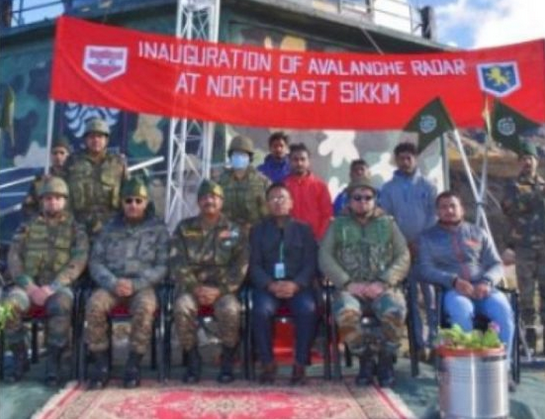
Gangtok: The Indian Army and the Defense Geoinformatics and Research Establishment (DGRE) have jointly installed the Avalanche Monitoring Radar, first of its kind in India, in north Sikkim, defence officials said on Friday. Besides being used for detection of avalanches, this Sikkim avalanche radar can also be employed to detect landslides.
Defence spokesman Lt. Col Mahendra Rawat said that the radar was inaugurated by Tri Shakti Corps commander, Lt Gen Tarn Kumar Aich, at one of the forward posts of the army at an altitude of 15,000 feet in north Sikkim.
The Sikkim avalanche radar has the capability to detect avalanches within three seconds of their triggering and will assist in saving valuable life of troops and civilians as also vehicles in super high altitude areas, he said.
Lt. Col Rawat said that the avalanche radar was made operational by Defense Research and Development Organisation’s wing DGRE, which is involved in forecasting and mitigation of avalanche hazards faced by Indian Army in the Himalayan region.
He said that this radar uses a series of short micro wave pulses which are scattered at the target and can detect an avalanche in less than three seconds.
The radar, which can permanently scan the targeted slope for avalanche release and track its path and its size in case it is triggered, can “see” through snow, fog as well as in the night, making it an all weather solution and covers an area of two sq/km obviating the requirement to place additional instruments in dangerous avalanche prone areas.
The radar is also linked to an alarm system enabling automatic control and warning measures in case an avalanche is triggered. Images and videos of the event are automatically recorded for future analysis by the experts.
Pragativadi News Service Sep 24, 2022
Special Radar Installed In Sikkim To Detect Landslides, Avalanche
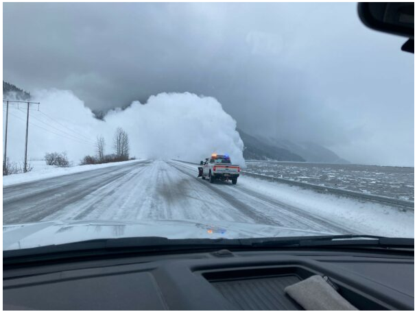
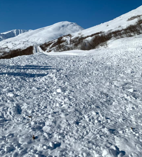
A Seward Highway avalanche closed the road for much of the day Friday. It was between Bird Creek and the Portage turnoff. The avalanche severed the only road access between Anchorage and the Kenai Peninsula for more than eight hours.
The Seward Highway avalanche hit at Mile 91.5 and the debris on the roadway was up to 15 feet high in spots, said a spokesperson for the DoT. The highway reopened around 2 p.m. but drivers should remain cautious.
“Travel is going to be wet and slick and bumpy. They’ve cleared all the snow but it’s definitely not down to dry highway measures by any means.”
Crews set off artillery to trigger 20 other avalanches along the highway on Friday. Also on Friday, several snow slides closed the Old Glenn Highway near the Old Knik River Bridge.
Farther north, snow slides near Summit Lake closed the Richardson Highway from mile 186 to 218.
The Hatcher Pass Avalanche Center also warned of very dangerous avalanche conditions in the area. It issued an avalanche warning early Friday, and it says the Hatcher Pass Road will be closed at mile 11 through the weekend due to avalanche activity.
National Weather Service meteorologist Michael Kutz said Anchorage has been having one of the wettest years on record so far. Snowfall this February is nearly three times higher than average, and rainfall this year is more than four times above normal, Kutz said.
Seward Highway Avalanche
Rain and Snow in Anchorage
Rain and snow have been falling in Anchorage and other areas of Southcentral since the beginning of the week. Which has led to treacherous road conditions in parts of town. Areas of the Mat-Su have been hit with heavy snow. Power to thousands of homes has been knocked out.
As of Friday evening, about 300 homes still did not have power. The Mat-Su school district canceled in-person classes on Friday for the third day in a row due to road conditions and winter weather.
Jan 20 – British Columbia is rolling out the artillery and bombs for avalanche bombing. There have been closures on some major roads for the first time in decades as the province grapples with record snowfall and rain.
The province, third-largest by population, uses helicopter avalanche bombing, remote-triggered explosives, and howitzers to keep roads open. But nonetheless critical routes to Vancouver are being disrupted by avalanche control.
Extreme weather, including November’s torrential precipitation, a deep freeze in late December and an early January thaw, has weakened the snowpack. Mountain slopes are more prone to avalanches that can release without warning.
Avalanche bombing requires closing sections of roads while teams use explosives to pre-emptively trigger slides, which prevents the snowpack from becoming deep and unstable.
Record amounts of control actions
A section of Highway 1 through Fraser Canyon northeast of Vancouver needed avalanche control for the first time in 25 years.
On Highway 99 north of Vancouver avalanche control actions are three times the seasonal average. Some paths have produced avalanches big enough to hit the highway for the first time in over a decade.
Avalanche bombing in Allison Pass further south on Highway 3 has also been above average.
These highways were all damaged in November by floods. A busy avalanche control season is putting further strain on resources. The Coquihalla Highway near Hope just reopened on Wednesday. And record snow along with avalanche risk delayed repairs to Highway 1 through the Fraser Canyon.
Rogers Pass
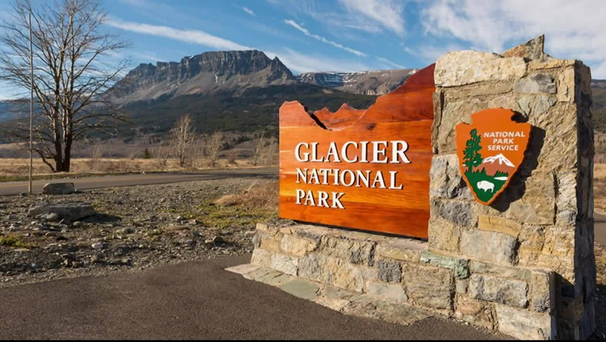
Further east avalanche teams in Rogers Pass, which runs below 135 slide paths in Glacier National Park, are dealing with more snow than usual. Control missions are also above average.
Approximately 3,000 vehicles traverse Rogers Pass every day in winter. A major Canadian Pacific rail line runs along the highway although it has a long tunnel under the top of the pass.
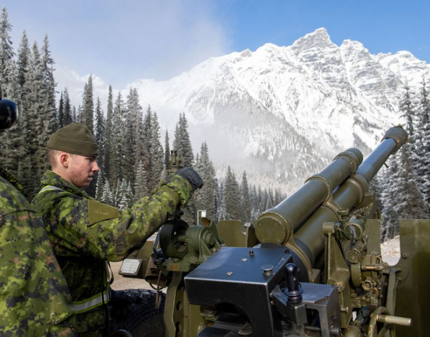
Rogers Pass avalanche bombing involves artillery soldiers who are stationed in Rogers Pass in winter. They use a howitzer to fire shells into loaded avalanche paths along the highway.
“Our goal is to bring down as much snow as we can and bring the hazard down to a point where it’s safe to open the highway,” said Jim Phillips, acting avalanche operations coordinator for Parks Canada.
The Rogers Pass program has been running since the highway opened in 1961. Before that, and before they built their tunnel, CP trains ran a high risk of deadly snow slides. One killed 62 railway workers in 1910.
So far this winter the team has fired 333 howitzer rounds, produced 197 controlled avalanches and closed the highway for 43 hours over seven separate days.
Helicopter Avalanche Bombing
Phillips said his team also uses heli-bombing and remote-trigger systems to set off detonations, and spends C$600,000 ($480,346) a year on explosives alone.
“It’s a balancing act. You want to keep traffic moving and minimize closures, but also minimize risk to people using the transportation corridor,” he added.
Avalanche control is typically needed until late April or early May.
November 22, 2019. MCpl PJ Letourneau/Canadian Forces. Avalanche bombing in Rogers Pass.
An avalanche trapped bikers on Thursday, May 13. At about 6:30 pm Glacier National Park rangers responded to a report of three bikers who were trapped behind an avalanche near Triple Arches on Going-to-the-Sun Road.
Three bikers – a husband and wife along with a friend – traveling up the road encountered an avalanche across the road, turned around, and started back down. Soon after, they encountered a second avalanche in progress. The wife was ahead of her husband and friend and heard the avalanche. She warned her husband and friend to stop. The avalanche came down between them. So the avalanche trapped bikers – the woman’s husband and friend – on the uphill side.
The wife biked down to call for help. A ranger arrived at the site of the avalanche around 7:30 pm.
Afternoon sun and warming were to blame
“The sudden onset of sunny and warm weather on Thursday afternoon, combined with recent new snow from the previous weekend, created unstable surface snow conditions,” said USGS scientist Erich Peitzsch. “These conditions resulted in a wet, loose avalanche originating above the road in Triple Arches that deposited debris on the road.”
Park officials determined that they would wait until the sun was off the slope above, decreasing the chances for further slides, before starting rescue attempts.
Rescue began around 9:30 pm. Rangers belayed across the avalanche chute and belayed the bikers individually back across the chute. No injuries were sustained by the bikers; all three are from Bigfork.
Going-to-the-Sun Road is currently closed to vehicles at Avalanche Creek until the road opens to Logan Pass for the season. Due to continued avalanche conditions, hiker/biker access is currently not permitted past the Loop. Check the park website for updates.
Park officials remind visitors that snow can avalanche above Going-to-the-Sun Road in active avalanche terrain that often cannot be seen from the road. Avalanches are more likely to occur before or after sunny/warm weather, rainstorms, or snowstorms. Visitors are encouraged to start and finish their trip before the warmest part of the day. Do not stop under gullies or snowfields and turn around if there is a rapid increase in temperature.
An avalanche trapped bikers on Going-to-Sun Road in Glacier Park
A Hatcher Pass avalanche blocked the road but it reopened just before 4 p.m. Friday
A large, remotely triggered Hatcher Pass avalanche covered the road around 12 p.m. on Friday. Hatcher Pass Avalanche Center posted photos of the avalanche. They said that the road would likely be closed at the Gold Mint parking lot. The avalanche did not involve any people.
Increased Avalanche Danger had been predicted
On March 25, the HPAC warned of an increased avalanche danger due to nearly a foot of new snow. Persistent slabs and storm slabs were likely problems. Later that day three observations of small avalanches were reported.
“No one was caught or carried it was people skinning on the standard Marmot uptrack and triggered a smaller avalanche and then it stepped down to the deeper layers in the snowpack” said HPAC Board Chair Andy Dennis.
Road Cleared of Avalanche Debris
The Department of Transportation and State Parks were alerted to clear the road. It was closed at the turn near the Gold Mint parking lot. Throughout the winter numerous skiers have been caught in small avalanches. Nobody has been buried and there have been no fatalities in Hatcher Pass. Palmer Fire and Rescue did assist other agencies in a rescue in Hatcher Pass on March 21.
“As we come into spring I think we have a tricky snowpack, so any new load is potentially going to awaken the persistent slab problem. These cold temperatures have not allowed the snowpack to heal at all and really just trying to make sure people are heads up coming into the longer, warmer days. It’s going to be A little bit delayed in terms of kind of the snowpack stabilizing,” said Dennis. “We’ve got a couple crust layers that are going to, what we’re thinking is most likely going to prohibit fast healing.”
The avalanche occurred just after 12 p.m. and the road was cleared at around 6 p.m.
Snow avalanche blocked the road Triloknath-Udaipur link near Shakoli village in tribal Lahaul-Spiti district today. The snow avalanche was triggered during the day, which brought the traffic movement on this road to a complete halt.
Heaps of snow covered the vast stretch of the road though no loss of life and property was reported.
Deputy Commissioner Lahaul Spiti Pankaj Rai said workforce and machinery have been deployed in the area to restore this link road for movement of vehicles.
As weather is getting warmer in the region, the incidents of snow avalanches were occurring frequently in Lahaul-Spiti. A few days ago snow avalanches were triggered at Karpat and Lobar under Udaipur sub division in the district.
A Snow avalanche blocked the road Triloknath-Udaipur link
Sat, Feb. 27 – Juneau’s urban avalanche forecast is for “extreme” Juneau avalanche danger as of Saturday evening. There is a potential for “historic avalanches” in residential areas. City officials recommend that residents in the avalanche zone in downtown Juneau evacuate their homes.
The advisory also recommends that residents avoid avalanche paths including the Flume Trail. “People need to make their own safety decisions,” it stated. “But we feel that with the forecast for the next 24 – 48 hours natural avalanches are likely and of great size.”
The city and the Red Cross will open Centennial Hall as an emergency shelter. The doors opened at 8:00 p.m. on Saturday. COVID-19 mitigation measures are in place.
Juneau Avalanche Warnings were issued Friday
Juneau city officials said on Friday that there is a potential for “historic avalanches”. Depending on temperatures and how much snow falls, the city’s Urban Avalanche Advisory could be raised to an “extreme” Juneau avalanche danger, which is the highest level on the scale.
“I have never forecasted an extreme avalanche condition,” said Tom Mattice, the city’s emergency programs manager. He advised residents to be cautious, especially near the Behrends Avenue avalanche path.
Mattice says they’ve recently seen avalanches of snow four to six feet deep throughout the region. “In the urban environment, if we have a four foot deep avalanche that’s wide enough across the face of the Behrends path, (then) that’s more than enough to hit houses,” he said.
Widespread Activity and increased hazards
The Alaska Department of Transportation & Public Facilities has warned of increased avalanche hazard along Thane Road. Residents along the road should be prepared for an extended road closure if crews are unable to safely remove any avalanche debris.
The Coastal Alaska Avalanche Center says they’ve already seen widespread avalanche activity all around Juneau. They expect more avalanches over the weekend.
Rain Crust
A freezing rain crust has formed on top of recent snow that fell on a weak snow layer. The snow’s weakness can even be triggered from a flat spot. “And then, it’ll travel through that freezing rain crust and collapse the looser snow below and the denser snow above. So it can travel great distances. We’ve already seen avalanches that have traveled over a quarter mile just from propagating through the snowpack.”
They’re warning people heading out to the backcountry to use extreme caution. Even in terrain that is generally considered safe from any avalanches.
He says the unstable snowpack conditions could potentially last through the rest of the season.
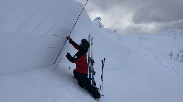
A ski patroller examines snow layers during avalanche mitigation. (Coastal Alaska Avalanche Center)
An unusually high number of avalanches in Iceland have fallen across East Iceland, North Iceland, and the Westfjords in mid-January. This is from the Icelandic Met Office. There were 133 reports of avalanches in Iceland in 10 days. But the true number is likely higher. The Civil Protection Department has declared an uncertainty phase in the North Westfjords. And also North and East Iceland. Because the risk continues.
Westfjords, Northeast Iceland, and Eastfjords
Most of the 133 reports were from the Westfjords (52) and Northeast Iceland (41). The third-highest number were reported in the Eastfjords (24). “It is clear that many more avalanches have occurred without being recorded. Many fall off the beaten track, others occur without being seen, and not all avalanches are reported.” Of course heavy snowfall is the cause. The snow blanketing the slopes is considered unstable. However, the office reports that some avalanches have fallen in still weather.
Roads Closed
Avalanches in Iceland have fallen on several roads across the country. Causing closures while snow is cleared. The Road and Coastal Administration notifies travelers of road closures across the country. The Met Office reports on avalanche risk.
No people have been injured as a result of the events. Though one recent avalanche in Skagafjörður killed at least three horses and destroyed a shed. One avalanche on the Skarðsdalur skiing grounds in North Iceland caused significant damage to the facilities. A third near Eskifjörður, East Iceland, damaged a shooting range and may have damaged facilities in the area as well.
Avalanches in Iceland are nothing new. There were catastrophic avalanches in the villages Súðavík and Flateyri in 1995. Which killed 34 people and caused extensive economic damage. Those avalanches made it clear that a substantial number of people in several Icelandic towns and villages live in areas where avalanche risk is unacceptable.